Within the framework of the major urban development projects planned by the canton of Geneva, the MIP group was asked to develop solutions for the representation of the territory and projects by digital mock-ups.
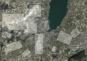
Currently, the canton of Geneva plans 10 major urban development projects to meet the housing needs of the inhabitants, to build high-quality areas and reduce movement between home and work, etc. As the work was planned to start between 2015 and 2018, the MIP group was asked to develop solutions to represent the territory and projects through digital mock-ups.
In order to meet the needs of decision-makers, project managers and stakeholders, the group developed a data model and execution routines, to then generate the basic frameworks of the territory in three dimensions and insert the planning and development projects in these frameworks.
The solutions developed allow rapid updates of projects over time to ensure short, medium and long term follow-up. Ultimately, the visualisation of projects in the territory’s digital mock-up serves the project, the decision-makers and the inhabitants, because, in addition to just providing an image, digital visualisation becomes a tool for communication, consultation and decision-making support in the project’s life cycle.
Project partner(s)
Project leader - team
Olivier Donzé
(HEPIA)